Hurricane Milton Safety Precautions
Dear Guests and Owners,
As Hurricane Milton approaches Florida, our top priority at Wonder Vacation Homes is the safety and well-being of all our guests and property owners. We are closely monitoring the situation and coordinating with local authorities to ensure we’re prepared for any potential impact. Hurricane Milton is expected to affect Central Florida as a Category 1 storm, and we want to keep you informed with the latest details:
Orlando Forecast and Storm Timeline:
- Storm Duration: Wednesday, 9 p.m. – Thursday, 6 p.m.
- Peak Winds: 70-90 mph, with gusts up to 100 mph, especially from Thursday, 8 a.m. – Thursday, 1 p.m.
- Rainfall: 10-15 inches expected overall.
- Peak Rainfall: Wednesday, 7 a.m. – Thursday, 11 a.m.
We are expecting Hurricane Milton to reach Central Florida as a Category 1 hurricane on Thursday morning around 8 a.m., lasting through Thursday evening until approximately 6 p.m.. Please take the necessary precautions to stay safe during this time.
Wonder Vacation Homes Preparations
We are pleased to report that the Wonder Vacation Homes team has done an outstanding job in preparing for the storm. We have successfully:
- Secured 100% of outdoor furniture and decorations by moving them inside the units.
- Closed and locked all windows and doors to ensure the safety of each property.
In addition, we are currently assisting several last-minute bookings to accommodate guests who have been evacuated from the coastal areas to seek safety in Central Florida. We still have 25% of our units available for booking, and we are ready to check you in immediately. If you or someone you know is searching for a safe place to stay during Hurricane Milton, you can book now at www.wondervacationhomes.com.
Important Safety Reminders for Our Guests:
- Ensure Your Space is Secure:
- Double-check that all windows and doors are closed and locked.
- Make sure the garage gate is closed and locked for extra safety.
- Do not attempt to open or fly the garage door during high winds.
- Charge All Devices:
- Ensure all electronics and batteries are fully charged.
- Keep flashlights on hand for potential power outages.
- Phones should be fully charged and kept nearby for communication.
- Seek Shelter in Safe Areas:
- In case of extreme winds, it’s recommended to stay on the lower floor of your vacation home.
- Closed spaces like pantries or storage rooms on the ground floor are usually the safest places to stay.
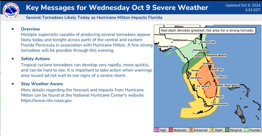
- Tornado Watch:
- Please be aware that we are now under a tornado watch, and the effects of Hurricane Milton are already being felt in the area. Follow all official instructions and updates.
- Follow Local News and Authorities:
- Stay informed by following updates from local news channels and official entities such as the National Weather Service and National Hurricane Center.
- Curfew Mandate:
- Osceola County is under a curfew effective from Wednesday, Oct. 9, 8 p.m. until Thursday, Oct. 10, 10 a.m., which may be extended depending on the hurricane’s progress. Please stay indoors and continue to monitor for further updates on curfew extensions.
DISCUSSION AND OUTLOOK
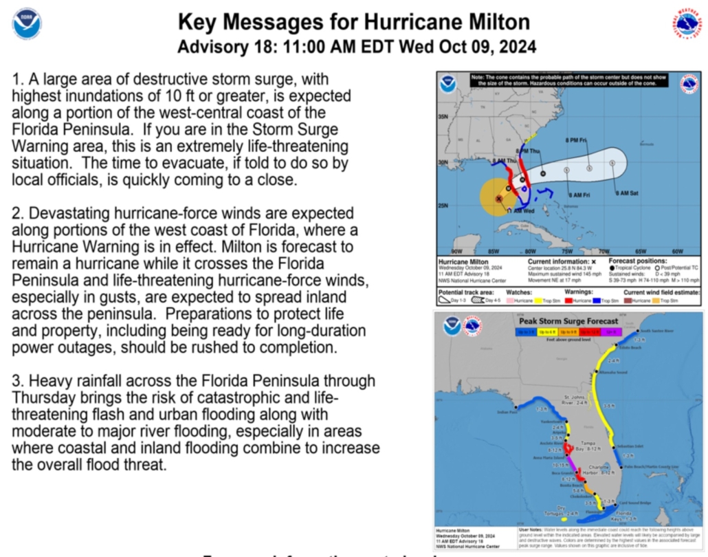
As of 2:00 PM EDT (1800 UTC), the center of Hurricane Milton was located near latitude 26.3 North, longitude 84.0 West. Milton is moving toward the north-northeast at approximately 16 mph (26 km/h). A shift toward the northeast with a slower pace is anticipated this evening and tonight. A turn toward the east-northeast and east is expected on Thursday and Friday.
On the forecast track, the center of Milton is expected to make landfall along Florida’s west-central coast tonight, then move across the Florida peninsula overnight into Thursday, reaching the Atlantic Ocean by Thursday evening.
- Maximum sustained winds: Near 130 mph (215 km/h), with higher gusts, categorizing Milton as a Category 4 hurricane on the Saffir-Simpson Hurricane Wind Scale.
- Hurricane-force winds: Extend outward up to 35 miles (55 km) from the center.
- Tropical-storm-force winds: Extend outward up to 250 miles (280 km), especially to the north.
Milton is expected to remain an extremely dangerous major hurricane upon making landfall, maintaining hurricane strength as it crosses the Florida peninsula through Thursday. Gradual weakening is anticipated once it moves eastward over the Atlantic, possibly becoming an extratropical storm by early Friday.
Important Contact Information:
- Emergency Services: 911 for immediate assistance
- Osceola County Emergency Management: osceola.org
- National Hurricane Center US: nhc.noaa.gov
- National Weather Service: weather.gov
- FEMA US: fema.gov
Stay safe, and rest assured that Wonder Vacation Homes is here to support you throughout this time. We are committed to ensuring your safety and keeping everyone informed.
Warm regards,
Bruno Scarabottolo
CFO, Wonder Vacation Homes

